Weather Alert in Nevada
Fire Weather Watch issued June 14 at 1:22PM PDT until June 16 at 11:00PM PDT by NWS Reno NV
AREAS AFFECTED: Northern Sierra Front - Carson City/Douglas/Storey/Southern Washoe/Eastern Lyon/Far Southern Lassen Counties; Southern Sierra Front - Alpine/Northern Mono/Southern Lyon/Western Mineral Counties; Lahontan Basin - Churchill and Eastern Mineral Counties
DESCRIPTION: The National Weather Service in Reno has issued a Fire Weather Watch for gusty winds and low humidity, which is in effect from Monday afternoon through Monday evening. * Affected Area...Fire Weather Zone 420 Northern Sierra Front including Carson City, Douglas, Storey, Southern Washoe, Western Lyon, and Far Southern Lassen Counties, Fire Weather Zone 421 Southern Sierra Front including Alpine, Northern Mono, Southern Lyon, and Western Mineral Counties and Fire Weather Zone 429 Lahontan Basin including Churchill and Eastern Mineral Counties. * Winds...West 20-25 mph with gusts up to 45 mph. * Humidity...Minimum humidity of 5-15% Monday afternoon with limited recoveries Monday morning of 20-30%. * Duration...3 to 6 hours * Impacts...The combination of gusty winds and low humidity can cause fire to rapidly grow in size and intensity before first responders can contain them.
INSTRUCTION: Avoid outdoor activities that can cause a spark near dry vegetation, such as yard work, target shooting, or campfires. Follow local fire restrictions. Check weather.gov/reno for updates and livingwithfire.info for preparedness tips.
Want more detail? Get the Complete 7 Day and Night Detailed Forecast!
Current U.S. National Radar--Current
The Current National Weather Radar is shown below with a UTC Time (subtract 5 hours from UTC to get Eastern Time).

National Weather Forecast--Current
The Current National Weather Forecast and National Weather Map are shown below.

National Weather Forecast for Tomorrow
Tomorrow National Weather Forecast and Tomorrow National Weather Map are show below.

North America Water Vapor (Moisture)
This map shows recent moisture content over North America. Bright and colored areas show high moisture (ie, clouds); brown indicates very little moisture present; black indicates no moisture.

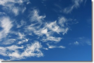
Weather Topic: What are Altostratus Clouds?
Home - Education - Cloud Types - Altostratus Clouds
 Next Topic: Cirrocumulus Clouds
Altostratus clouds form at mid to high-level altitudes
(between 2 and 7 km) and are created by a warm, stable air mass which causes
water vapor
to condense as it rise through the atmosphere. Usually altostratus clouds are
featureless sheets characterized by a uniform color.
In some cases, wind punching through the cloud formation may give it a waved
appearance, called altostratus undulatus. Altostratus clouds
are commonly seen with other cloud formations accompanying them.
Next Topic: Cirrocumulus Clouds
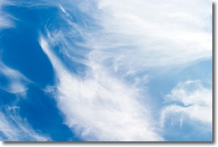
Weather Topic: What are Cirrostratus Clouds?
Home - Education - Cloud Types - Cirrostratus Clouds
 Next Topic: Cirrus Clouds
Cirrostratus clouds are high, thin clouds that form above
20,000 feet and are made mostly of ice crystals. They sometimes look like giant
feathers, horse tails, or curls of hair in the sky.
These clouds are pushed by the jet stream and can move at high speeds reaching
100 mph.
What do they indicate?
They indicate that a precipitation is likely within 24 hours.
Next Topic: Cirrus Clouds
Current conditions powered by WeatherAPI.com


