Weather Alert in Georgia
Flood Watch issued August 3 at 7:41PM EDT until August 4 at 8:00PM EDT by NWS Peachtree City GA
AREAS AFFECTED: Dade; Walker; Catoosa; Whitfield; Murray; Gilmer; Chattooga; Gordon; Pickens; Dawson; Floyd; Bartow; Cherokee; Forsyth; Polk; Paulding; Cobb; North Fulton; Gwinnett; Haralson; Carroll; Douglas; South Fulton; DeKalb; Rockdale; Walton; Newton; Morgan; Heard; Coweta; Fayette; Clayton; Spalding; Henry; Butts; Jasper; Putnam; Troup; Meriwether; Pike; Upson; Lamar; Monroe; Jones; Baldwin; Harris; Talbot; Taylor; Crawford; Bibb; Twiggs; Wilkinson; Muscogee; Chattahoochee; Marion; Schley; Macon; Peach; Houston; Bleckley; Laurens; Stewart; Webster; Sumter; Dooly; Crisp; Pulaski; Wilcox; Dodge; Telfair; Wheeler
DESCRIPTION: * WHAT...Flooding caused by excessive rainfall continues to be possible. * WHERE...Portions of central, north central, northwest, and west central Georgia, including the following areas, in central Georgia, Baldwin, Bibb, Bleckley, Butts, Crawford, Crisp, Dodge, Dooly, Houston, Jasper, Jones, Laurens, Monroe, Peach, Pulaski, Putnam, Telfair, Twiggs, Wheeler, Wilcox and Wilkinson. In north central Georgia, Cherokee, Clayton, Cobb, Dawson, DeKalb, Douglas, Fayette, Forsyth, Gilmer, Gwinnett, Henry, Morgan, Newton, North Fulton, Pickens, Rockdale, South Fulton and Walton. In northwest Georgia, Bartow, Carroll, Catoosa, Chattooga, Dade, Floyd, Gordon, Haralson, Murray, Paulding, Polk, Walker and Whitfield. In west central Georgia, Chattahoochee, Coweta, Harris, Heard, Lamar, Macon, Marion, Meriwether, Muscogee, Pike, Schley, Spalding, Stewart, Sumter, Talbot, Taylor, Troup, Upson and Webster. * WHEN...Through Monday evening. * IMPACTS...Excessive runoff may result in flooding of rivers, creeks, streams, and other low-lying and flood-prone locations. Flooding may occur in poor drainage and urban areas. * ADDITIONAL DETAILS... - A very moist airmass will remain in place across the region over the next several days. Multiple rounds of scattered to numerous showers and thunderstorms are expected across much of north and central Georgia through Monday. Widespread 1 to 3 inch totals with isolated totals up to 5 inches have already been observed within the watch area since Saturday. Additional rainfall of 2 to 4 inches with higher amounts up to 5 inches remain possible through Monday evening. - http://www.weather.gov/safety/flood
INSTRUCTION: You should monitor later forecasts and be alert for possible Flood Warnings. Those living in areas prone to flooding should be prepared to take action should flooding develop.
Want more detail? Get the Complete 7 Day and Night Detailed Forecast!
Current U.S. National Radar--Current
The Current National Weather Radar is shown below with a UTC Time (subtract 5 hours from UTC to get Eastern Time).

National Weather Forecast--Current
The Current National Weather Forecast and National Weather Map are shown below.

National Weather Forecast for Tomorrow
Tomorrow National Weather Forecast and Tomorrow National Weather Map are show below.

North America Water Vapor (Moisture)
This map shows recent moisture content over North America. Bright and colored areas show high moisture (ie, clouds); brown indicates very little moisture present; black indicates no moisture.

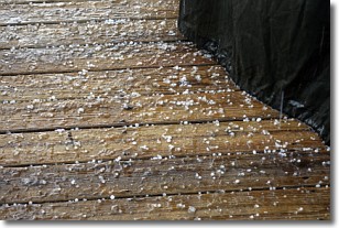
Weather Topic: What is Sleet?
Home - Education - Precipitation - Sleet
 Next Topic: Snow
Sleet is a form of precipitation in which small ice pellets are the primary
components. These ice pellets are smaller and more translucent than hailstones,
and harder than graupel. Sleet is caused by specific atmospheric conditions and
therefore typically doesn't last for extended periods of time.
The condition which leads to sleet formation requires a warmer body of air to be
wedged in between two sub-freezing bodies of air. When snow falls through a warmer
layer of air it melts, and as it falls through the next sub-freezing body of air
it freezes again, forming ice pellets known as sleet. In some cases, water
droplets don't have time to freeze before reaching the surface and the result is
freezing rain.
Next Topic: Snow
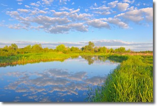
Weather Topic: What are Stratocumulus Clouds?
Home - Education - Cloud Types - Stratocumulus Clouds
 Next Topic: Stratus Clouds
Stratocumulus clouds are similar to altocumulus clouds in their
fluffy appearance, but have a slightly darker shade due to their additional mass.
A good way to distinguish the two cloud types is to hold your hand out and measure
the size of an individual cloud; if it is the size of your thumb it is generally
an altocumulus cloud, if it is the size of your hand it is generally a
stratocumulus cloud.
It is uncommon for stratocumulus clouds to produce precipitation, but if they do
it is usually a light rain or snow.
Next Topic: Stratus Clouds
Current conditions powered by WeatherAPI.com


