Weather Alert in Wyoming
Red Flag Warning issued August 3 at 1:08PM MDT until August 8 at 6:00PM MDT by NWS Cheyenne WY
AREAS AFFECTED: Central and West Carbon; Southwest Carbon County; Sierra Madre Range/Medicine Bow NF; Upper North Platte River Basin; Snowy Range/Medicine Bow NF
DESCRIPTION: ...MULTI-DAY CRITICAL FIRE WEATHER CONDITIONS ARE EXPECTED THIS WEEK WITH LITTLE OVERNIGHT RELIEF... .A multi-day critical fire weather event is expected this week due to low RH values into the teens and single digits, alongside poor overnight recoveries and gusty winds. Overnight recoveries may rise a little higher or winds a bit less breezy on some days, but overall conditions will be poor for a majority of the week. The National Weather Service in Cheyenne has issued a Red Flag Warning, which is in effect from noon Monday to 6 PM MDT Friday. * AFFECTED AREA...Fire weather zones 422, 423, 424, 425, and 426. * WIND...Gusting 20-30 mph, isolated gusts 35-40 mph. * HUMIDITY...5 to 15 percent; overnight recoveries 25 to 45 percent. * IMPACTS...any fires that develop will likely spread rapidly. Outdoor burning is not recommended.
INSTRUCTION: A Red Flag Warning means that critical fire weather conditions are either occurring now, or will shortly. A combination of strong winds, low relative humidity, and warm temperatures can contribute to extreme fire behavior.
Want more detail? Get the Complete 7 Day and Night Detailed Forecast!
Current U.S. National Radar--Current
The Current National Weather Radar is shown below with a UTC Time (subtract 5 hours from UTC to get Eastern Time).

National Weather Forecast--Current
The Current National Weather Forecast and National Weather Map are shown below.

National Weather Forecast for Tomorrow
Tomorrow National Weather Forecast and Tomorrow National Weather Map are show below.

North America Water Vapor (Moisture)
This map shows recent moisture content over North America. Bright and colored areas show high moisture (ie, clouds); brown indicates very little moisture present; black indicates no moisture.

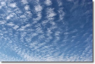
Weather Topic: What are Cirrocumulus Clouds?
Home - Education - Cloud Types - Cirrocumulus Clouds
 Next Topic: Cirrostratus Clouds
Cirrocumulus clouds form at high altitudes (usually around 5 km)
and have distinguishing characteristics displayed in a fine layer of
small cloud patches. These small cloud patches are sometimes referred to as
"cloudlets" in relation to the whole cloud formation.
Cirrocumulus clouds are formed from ice crystals and water droplets. Often, the
water droplets in the cloud freeze into ice crystals and the cloud becomes a
cirrostratus cloud. Because of this common occurrence, cirrocumulus cloud
formations generally pass rapidly.
Next Topic: Cirrostratus Clouds
Weather Topic: What are Cirrus Clouds?
Home - Education - Cloud Types - Cirrus Clouds
 Next Topic: Condensation
Cirrus clouds are high-level clouds that occur above 20,000 feet
and are composed mainly of ice crystals.
They are thin and wispy in appearance.
What do they indicate?
They are often the first sign of an approaching storm.
Next Topic: Condensation
Current conditions powered by WeatherAPI.com


