Weather Alert in Texas
Flood Warning issued June 14 at 9:07AM CDT by NWS Houston/Galveston TX
AREAS AFFECTED: Polk, TX; San Jacinto, TX; Trinity, TX; Walker, TX
DESCRIPTION: ...The Flood Warning is extended for the following rivers in Texas... San Bernard River near Sweeny affecting Brazoria County. San Bernard River near Boling affecting Fort Bend, Brazoria and Wharton Counties. Tres Palacios River near Midfield affecting Wharton and Matagorda Counties. ...The Flood Warning continues for the following rivers in Texas... Trinity River near Crockett affecting Madison, Houston, Trinity and Walker Counties. Trinity River at Riverside affecting Walker, San Jacinto, Polk and Trinity Counties. Trinity River near Moss Bluff affecting Chambers and Liberty Counties. Navasota River near Normangee affecting Grimes, Madison and Brazos Counties. For the Trinity River...including Crockett, Riverside, Moss Bluff, Liberty...Moderate flooding is forecast. For the Navasota River...including Normangee...Major flooding is forecast. For the Tres Palacios River...including Midfield...Moderate flooding is forecast. * WHAT...Minor flooding is occurring and moderate flooding is forecast. * WHERE...Trinity River at Riverside. * WHEN...Until further notice. * IMPACTS...At 136.0 feet, Moderate lowland flooding begins in the vicinity of the gage. The lowest homes in the Green Rich Shores Subdivision are flooded and Thomas Lake Road is inundated and impassable. Low-lying roads in the Deep River Plantation Subdivision are inundated. The lowest roads into properties off FM 980 northwest of Riverside are inundated and the lowest buildings are threatened. * ADDITIONAL DETAILS... - At 8:30 AM CDT Saturday the stage was 135.9 feet. - Bankfull stage is 133.0 feet. - Recent Activity...The maximum river stage in the 24 hours ending at 8:30 AM CDT Saturday was 135.9 feet. - Forecast...The river is expected to rise to 136.4 feet early Thursday morning. Additional rises are possible thereafter. - Flood stage is 133.5 feet. - Flood History...This crest compares to a previous crest of 136.7 feet on 03/21/2016. - http://www.weather.gov/safety/flood
INSTRUCTION: Motorists should not attempt to drive around barricades or drive cars through flooded areas. Please report observed flooding to local emergency services or law enforcement and request they pass this information to the National Weather Service when you can do so safely. Turn around, don't drown when encountering flooded roads. Most flood deaths occur in vehicles. Additional information is available at www.weather.gov/hgx. The next statement will be issued by late tonight at 315 AM CDT.
Want more detail? Get the Complete 7 Day and Night Detailed Forecast!
Current U.S. National Radar--Current
The Current National Weather Radar is shown below with a UTC Time (subtract 5 hours from UTC to get Eastern Time).

National Weather Forecast--Current
The Current National Weather Forecast and National Weather Map are shown below.

National Weather Forecast for Tomorrow
Tomorrow National Weather Forecast and Tomorrow National Weather Map are show below.

North America Water Vapor (Moisture)
This map shows recent moisture content over North America. Bright and colored areas show high moisture (ie, clouds); brown indicates very little moisture present; black indicates no moisture.

Weather Topic: What are Altostratus Clouds?
Home - Education - Cloud Types - Altostratus Clouds
 Next Topic: Cirrocumulus Clouds
Altostratus clouds form at mid to high-level altitudes
(between 2 and 7 km) and are created by a warm, stable air mass which causes
water vapor
to condense as it rise through the atmosphere. Usually altostratus clouds are
featureless sheets characterized by a uniform color.
In some cases, wind punching through the cloud formation may give it a waved
appearance, called altostratus undulatus. Altostratus clouds
are commonly seen with other cloud formations accompanying them.
Next Topic: Cirrocumulus Clouds
Weather Topic: What are Cirrostratus Clouds?
Home - Education - Cloud Types - Cirrostratus Clouds
 Next Topic: Cirrus Clouds
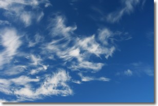
Cirrostratus clouds are high, thin clouds that form above
20,000 feet and are made mostly of ice crystals. They sometimes look like giant
feathers, horse tails, or curls of hair in the sky.
These clouds are pushed by the jet stream and can move at high speeds reaching
100 mph.
What do they indicate?
They indicate that a precipitation is likely within 24 hours.
Next Topic: Cirrus Clouds
Current conditions powered by WeatherAPI.com


